Showing posts with label Water. Show all posts

Friday, August 28, 2020

Alberni Valley - Victoria Quay

The West Coast of Vancouver Island (as in Ucluelet, Tofino, and Long Beach) had been closed to us (2020-06-13) due to Covid19. Nonetheless, we decided to take a drive out to Alberni (very much open to visitors). Victoria Quay was a pleasant stroll.

Alberni Valley - Victoria Quay (2020-06-13)


Cowichan Valley - Genoa Bay

July 5, 2020 found us travelling south to check out a lake near Chemainus. Later we decided to travel on to Genoa Bay. We hadn't been there in quite some time. This postcard is iconic.

Cowichan Valley - Genoa Bay (2020-07-05)


Nanoose - Brickyard Beach

During the last few weeks - June 2020 - we've been exploring numerous Salish Sea beaches along Vancouver Island's eastern shore. My motivation was the many streets and roads that dead-end at the water's edge (Google Maps was a great resource!).

Brickyard Beach (2020-06-09)


Monday, July 17, 2017

Swartz Bay - Ferry passing Piers Island

On this day (2016-09-25), we're on our way to Mayne Island with Darryl and Gail. The first step in our mini-vacation (not counting the drive from home to Swartz Bay) was taking the ferry for Village Bay on Mayne Island. Here, leaving Swartz Bay, Piers Island was particularly photogenic.

Piers Island; ferry leaving Swartz Bay...

Wednesday, April 1, 2015

Victoria - Bridge over the Esquimalt Lagoon

Ocean Boulevard bridge at the Esquimalt Lagoon. A place to stroll that affords a good view of the Fisgard Lighthouse.

Victoria - Bridge over the Esquimalt Lagoon
Google Maps:

Tuesday, March 31, 2015

Ucluelet - MV Frances Barkley leaving Barkley Sound, entering Ucluelet

In 2009 we treated ourselves to a "cruise". In this case, at $72 per person, the cruise was from Port Alberni to Ucluelet and return, aboard the MV Frances Barkley. Well worth the money.

Our postcard features the MV Frances Barkley leaving Barkley Sound, entering Ucluelet harbour.   (2009-06-07)

MV Frances Barkley leaving Barkley Sound into Ucluelet

Wednesday, March 25, 2015

Nanaimo - Bridge over the Nanaimo River at Cedar

Bridge over the Nanaimo River at Cedar (2013-12-31)

Bridge over the Nanaimo River at Cedar (2013-12-31)
Bridge over the Nanaimo River at Cedar (2013-12-31) 

Parksville - Englishman River Falls

Englishman River Falls (2013-09-05). A short walk with Marco and Angela, visiting from Bremen.

Englishman River Falls (2013-09-05). A short walk with Marco and Angela, visiting from Bremen.

Thursday, March 19, 2015

Genoa Bay - Bouthouse Reflections

Genoa Bay is one of our favourite destinations. We love the drive. We love the restaurant and its idyllic views. I couldn't have asked for better conditions for this postcard.
Genoa Bay - Bouthouse Reflections (2013-11-16)

Friday, December 20, 2013

Cowichan Bay - What constitutes a Backyard in Cow Bay

Cowichan Bay (Cow Bay to the locals) is nothing if not "funky". It's fun to contemplate what it would be like to have a backyard as depicted here. 

What constitutes a Backyard in Cowichan Bay (2011-05-21)

Van Anda, Texada Island - Fishing Pier Perspective

It was late in August and I was camping at Mouat Bay with Barb, Sean, Lee, and a cast of thousands (#exaggeration). Camping on the western side of Texada Island generally also includes a trip to Van Anda, on the eastern shore. And, when in Van Anda, a stop at the pier is "must see BC".

Vanada, Texada Island - Fishing Pier Perspective (2012-08-27)

Nanoose Bay - Trail leading to Clam Beds

Hanne had heard that moonsnail shells were to be found in abundance at the Nanoose Bay beach. On a low tide in early July, we drove out to have a look and for Hanne to go "collecting". She was in luck. By a small parking lot, this little trail leads to the beach.

When walking about at lower tides, be careful to respect the various commercial clam/oyster beds in the area.

Nanoose Bay - Trail leading to Clam Beds (2012-07-06)

Quadra Island - Sailing past the Rebecca Spit Light

Since Britta had a few days off, we decided on a camping trip up Vancouver Island. Up island, however, meant rain clouds the further north we got. We looked eastward and noticed brighter skies over Quadra Island, and brighter yet beyond that. Beyond that, as far as our world was concerned, meant Cortes island. So, that where we headed. While on the ferry for Whaletown, on Cortes Island, my camera caught this sailboat passing by the navigation light at Rebecca Spit on cotrtes Island.

Quadra Island - the Rebecca Spit Light (2011-07-11)

Thursday, September 26, 2013

Alberni Valley - McLean Sawmill Historic Site

After spending a few hours walking about Stamp River Provincial Park, on the road back to Port Alberni, we spotted a directional sign to the National Historic site at the old McLean sawmill. Curious, we turned off the road to see what this was all about. Happily, after we parked the car, we noticed that coffee and a bite to eat were available at a little snack bar. Before we could even get our bearings, a gentleman, dressed in the garb of an old-time train conductor, ushered us past the snack bar, "If you hurry, you'll catch the show." We did catch the show (real live old-time loggers - yes, we call them loggers, not lumberjacks - showing how things used to be done), and made a note to come back here with our next Vancouver Island visitors. Here's the day's postcard.
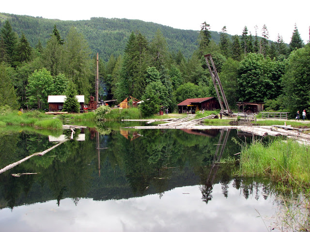

McLean Sawmill Historic Site (2011-06-25)

Sunday, September 22, 2013

Nanaimo - November stroll at Neck Point Park

It's not often that Nanaimo is graced by sunshine in November. On this particular day, a leafless tree silhouette, in Neck Point Park, provided a postcard frame for a chilly Salish Sea.

A rare sunny November view of the British 
Columbia mainland across the Salish Sea (2012-11-26) 

Wednesday, September 11, 2013

Royston - Red Railing

Pardon the title alliteration.

I can't count the number of times we've driven by the Royston turn-off on Highway 19a (known locally as the Oceanside Route or the Old Island Highway) with hardly a thought to actually having a look. On this day in August, after poking around Comox (I think we checked out the new Costco there), the mood just hit me; "why not take a drive down to the water?" We found this little pier right at the end of Royston Road, where it intersects with Marine Drive.

The view here is of Comox (Port Augusta as it was known in earlier times - circa 1860).

Royston; The view here, is of Comox (Port Augusta as it was known in earlier times - circa 1860) (2011-08-10)
Royston; The view here, is of Comox (2011-08-10)


Sunday, September 8, 2013

Nanaimo - Colliery Dam; this may soon be gone

The Colliery Dam Park in Nanaimo is being "reconfigured" and this may soon be gone. A postcard view in remembrance.


The Colliery Dam Park in Nanaimo (2012-02-15)

The Colliery Dam Park in Nanaimo (2012-02-15)


Tuesday, September 3, 2013

Port Alberni - Wooden Eagle takes flight

After a long road trip, coming back from Ucluelet, Tofino, and Long Beach, we stop by the quay at Port Alberni for a cup of coffee and a little snoop about. The wind was blowing fairly hard, and this carved eagle seemed to be taking flight.

Eagle takes flight in wind funnelling up the Alberni Channel (2013-07-12)
  Eagle takes flight in wind funnelling
up the Alberni Channel (2013-07-12)

Tuesday, August 13, 2013

Victoria - Iconic Postcard View

This may well be 999,999th photo with this view but, so be it. It is what it is: Victoria in the summer.

And, lest we forget, the words of James Douglas upon setting sights on the area that is now Victoria:
Open spaces of verdant meadow were a welcome contrast to thick dark forest on other parts of the coast. In a letter to James Hargrave, Douglas described the scene: “The place itself appears a perfect ‘Eden’ in the midst of the dreary wilderness of the North...one might be pardoned for supposing it had dropped from the clouds into its present position.” (James Douglas to James Hargrave, February 5, 1843, G. P. de T. Glazebrook, ed. The Hargrave Correspondence, p. 420)

View Of Victoria's Inner Harbour (2009-07-21)


Monday, August 12, 2013

Ladysmith - A Working Harbour

While kayaking out of Transfer Beach in Landysmith, it became abundantly clear that this is a "working harbour". Plenty of log booms, saw-milling activity, and the boom boat I managed to capture for this postcard.

Leaving no doubt that Ladysmith is a working harbour


070821